 |
 |
Home |
 |
Products |
|
StratFrame4.5 |
|
|
|
1. Outline
StratFrame4.5 is a digital mapping software based on geologic research and oilfield development. The software can draw various conventional maps for geologic and development research automatically, such as individual reservoir plan, contour map, current status of reservoir development, histogram, reservoir section, fence diagram, etc. It still can provide analysis tools for reserve calculation and overlap of area. It provides convenient data management, professional digital mapping, and powerful image processing function. Because of its multiple functions, StratFrame4.5 provides a friendly interface, easy operation, intuitive digital mapping tool for the development of geology research and reservoir analysis.
2. Business Functions
(1)Draw and Analyze Individual Reservoir Plan
Individual reservoir plan:According to geological information and individual reservoir data, The software can create sand pinchout boundary, oil-bearing zeroline, oil-water boundary, and then generate reservoir area map and oil-bearing area map.
Reserve calculation: It provides reserve calculation according to the oil-bearing area and effective thickness, etc.
|
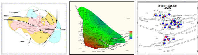 |
(2)Generate Various Types of Contour Quickly
The software can automatically create various chorisogram, such as structure contour ,sand and effective net sand isopach map, effective thickness contour , porosity and permeability contour, SW map, etc. In addition, it can be imported such as structure contour or attribute contour in seismic data interpretation. |
(3)Draw Exploitation Status Maps Combined Dynamic and Static Data
Based on the static geological maps, it can draw current status of reservoir development combing information on oil and water wells in the dynamic databases, and carry on reservoir performance analysis.
|
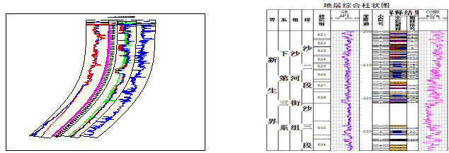
(4)Draw Various Types of Geological Histogram with Template
It can transform substandard las file, splice las files of same well, and import batch of las files. Users can save drawn histogram as template, or use system templates to create quickly geological histogram of the same type.
|
 |
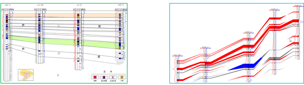
(5)Draw Reservoir Sections
The Reservoir sections are created according to the well drilling data and logging data. They can reflect the structural feature, formation lithology, reservoir physical properties and oil-gas-water distribution. The software can generate stratigraphic correlation diagram simultaneously.
|
 |
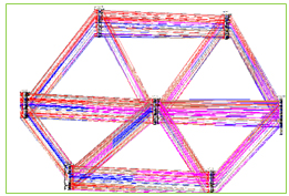
(6)Analyze Grid Connected Section
The software can create grid connected section which reflects the sand-connected conditions. Users can add various data to the grid connected section such as lithology, fossil, stratification, log presentation and so on. StratFrame4.5 provides fence diagram for development geologists to readjustment of injection-production plan.
|
 |
4. Application
The software is widely used in Shengli Oilfield, and the work efficiency and reuse of maps has been greatly improved. It helps geologists to invest more time and energy in geological study. The software can draw normalized and specialized accuracy maps, so it has been highly appraised and recognized by customers. StratFrame4.5 became the main digital geological mapping software in Shengli Oilfield.
|
Company Name: V-petrotek,LLC
Internet site: www.v-petrotek.com
Contact: Chonghai Fan
Tel:7134580246
Email: fanchonghai@victorysoft.com.cn |
|
|
|
|